
DbSchema | SQL Server - How to Use Spatial Data Types?
SQL Server: How to Use Spatial Data Types in sqlcmd and DbSchema
![]()
Table of Contents
- Introduction
- Prerequisites
- What are Spatial Data Types?
- Why Use Spatial Data Types?
- Restrictions and Permissions
- Advantages and Limitations
- Types of Spatial Queries
- Using Spatial Data Types in sqlcmd and DbSchema
- Conclusion
- References
Introduction
SQL Server, the widely used relational database management system by Microsoft, provides advanced capabilities for the handling and manipulation of geographical and geometric data through its Spatial Data Types. In this article, we are going to delve deep into understanding these spatial data types, their purposes, advantages, limitations, and the restrictions and permissions required to use them. We will also look at how to employ these data types in sqlcmd and DbSchema, alongside explaining the different types of spatial queries with examples.
Prerequisites
Before moving forward, ensure you have:
- A basic understanding of SQL (Structured Query Language).
- SQL Server Management Studio installed.
- Basic knowledge of sqlcmd utility and DbSchema.
- Access to a SQL Server instance for practice.
For installation and establishing connection you can read our article SQL Server-How to create a database?
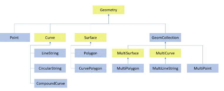
What are Spatial Data Types?
Spatial data types are used to represent geographical or geometric data. In SQL Server, two spatial data types are provided - geometry and geography. The geometry type is used to store planar (flat) shapes, while the geography type is used to store spherical (round) shapes, representing the earth’s surface.
Why Use Spatial Data Types?
Spatial data types enable storage, retrieval, and querying of geographical and geometric data within a database. This means data that represents physical locations and shapes can be used in your applications. They are extensively used in applications like Geographic Information Systems (GIS), logistics, and many others, making the handling of such data efficient and straightforward.
Restrictions and Permissions
To use spatial data types in SQL Server, the user must have at least db_datareader and db_datawriter roles, or equivalent permissions. Furthermore, certain methods associated with these types are available only if the database is set to compatibility level 100 or higher.
Advantages and Limitations
Advantages:
- Allow you to store complex geographic and geometric data.
- Provide a variety of built-in functions for manipulating spatial data.
- Enable location-based queries and operations.
Limitations:
- Complex to understand and use for beginners.
- The precision of calculations may be affected due to the Earth’s round shape (for geography data type).
- Requires a substantial understanding of the underlying mathematical concepts.
Types of Spatial Queries
Spatial queries can be broadly classified into three categories:
| Query Type | Description |
|---|---|
| Nearness Queries | These queries help in finding out how close one geographical point is to another. |
| Region Queries | These queries allow us to search within a specified geographical region. |
| Union/Intersection Queries | These queries enable us to find the common area between two geographical entities or combine them. |
Using Spatial Data Types in sqlcmd and DbSchema
In this section, we will look at the steps to use spatial data types in sqlcmd and DbSchema.
Using Spatial Data Types in sqlcmd
Step 1: Start sqlcmd from the command prompt using the following command.
|
Replace localhost, sa, and your_password with your SQL Server instance’s address, username, and password, respectively:
Step 2: Create a new database named SpatialDB and switch to it:
|
Step 3: Create a table named Locations with three columns: ID, Name, and Location. ID is an integer that automatically increments with each new row. Name is a variable-length string. Location is a geography spatial data type:
|
Step 4: Insert a row into Locations. The Name is OpenAI HQ, and the Location is a point that corresponds to the latitude and longitude of OpenAI HQ. The 4326 SRID (Spatial Reference Identifier) is used for the WGS 84 spatial reference system, which is the standard for GPS and cartography:
|
Step 5: Run a select query to return all rows from Locations where the Name is OpenAI HQ:
|
Assuming the table only contains the row we’ve inserted, the output would be something like:
| ID | Name | Location |
|---|---|---|
| 1 | OpenAI HQ | 0xEA70C66C713225C9CF189F7E37B94249716823B0 |
Here, the Location is represented as a hexadecimal number. If you want to see it as human-readable text, you can use the ToString() method:
|
The output would then be:
| ID | Name | Location |
|---|---|---|
| 1 | OpenAI HQ | POINT (-122.4194 37.7749) |
These results indicate that we have a location named OpenAI HQ stored in our database, and its geographical coordinates correspond to a latitude of 37.7749 and a longitude of -122.4194.
Using Spatial Data Types in DbSchema
DbSchema is a visual database design tool. Once you have connected DbSchema to your SQL Server instance, you can use its Graphical Query Builder and SQL Editor to execute queries. You can also visually design the database layout.
Follow the steps 2-4 mentioned in the sqlcmd section to create a database, table, and insert data. DbSchema will visually represent the database schema.
To execute a query in DbSchema:
- Click on SQL Editor on the top bar.
- Type your SQL query in the editor. For example:
|
- Press the Run SQL (F5) button or hit F5 on your keyboard.
- The result set will appear at the bottom of the SQL Editor.
Since DbSchema is a GUI tool, you can see the actual points on a map if the result includes geographic data. You just have to switch to Geographic View in the result set viewer. This feature makes DbSchema particularly powerful for working with spatial data types.
Remember, using spatial data types can initially be complex due to the mathematical concepts involved. However, once understood, it opens up a whole new dimension of possibilities in database design and query.
Visually Manage SQL Server using DbSchema
DbSchema is a SQL Server client and visual designer. DbSchema has a free Community Edition, which can be downloaded here.
Key Features of DbSchema:
Following are the key features of DbSchema which distinguish it from other database GUI tools.
Conclusion
The capability of SQL Server to handle spatial data types provides a comprehensive solution to manage geographic and geometric data in applications. Though it may seem complex, understanding the underlying concepts and working with sqlcmd and DbSchema can streamline the process, opening new horizons in application development.